

Presentation
Many visitors choose Tanzania as destination, because of its Beauty of Nature. Tanzania has a great potential to become an major adventure tourism destination. Ecotourism has also a potential growth in Tanzania.
Tanzaniahas a varied geography, including deep and large freshwater and salt lakes, many national parks, and Africa’s highest point. As a land of geographical extremes, Tanzania houses the highest peak, Mount Kilimanjaro (5,895 m), the lowest point (the lake bed of Lake Tanganyika), and a portion of the largest lake (Lake Victoria, shared with Uganda and Kenya) on the African continent.
Geographical description
Tanzania is mountainous and densely forested in the northeast, where Mount Kilimanjaro is located. Three of Africa’s Great Lakes are partly within Tanzania. To the north and west lie Lake Victoria, Africa’s largest lake, and Lake Tanganyika, the continent’s deepest lake, known for its unique species of fish. To the southwest lies Lake Nyasa. Central Tanzania is a large plateau, with plains and arable land. The eastern shore is hot and humid, with the Zanzibar Archipelago just offshore.
Northeast Tanzania is mountainous and includes Mount Meru, an active volcano, Mount Kilimanjaro, a dormant volcano, and the Usambara and Pare mountain ranges. Mount Kilimanjaro attracts thousands of adventure tourists and trekkers each year. A large central plateau makes up most of the mainland, at between 900 m and 1,800 m. The mountain ranges of the Eastern Arc and the Southern and Northern Highlands cut across the country to form part of the Great Rift Valley.
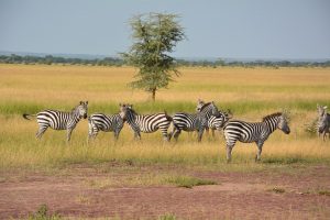
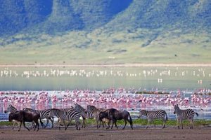
West of those mountains is the Gregory Rift, which is the eastern arm of the Great Rift Valley. On the floor of the rift are a number of large salt lakes, including Natron in the north, Manyara in the south and Eyasi in the southwest. The rift also encompasses the Crater Highlands, which includes the Ngorongoro Conservation Area and the Ngorongoro Crater. Just to the south of Lake Natron is Ol Doinyo Lengai (3,188 m), the world’s only active volcano to produce natrocarbonatite lava. To the west of the Crater Highlands lies Serengeti National Park, which is famous for its lions, leopards, elephants, rhinoceroses, and buffalo plus the annual migration of millions of white bearded wildebeest. Just to the southeast of the park is Olduvai Gorge, where many of the oldest hominid fossils and artifacts have been found.
Further northwest is Lake Victoria on the Kenya–Uganda–Tanzania border. This is the largest lake in Africa by surface area and is traditionally named as the source of the Nile River. Southwest of this, separating Tanzania from Congo-Kinshasa is Lake Tanganyika. This lake is estimated to be the second deepest lake in the world after Lake Baikal in Siberia. The western portion of the country between Lakes Victoria, Tanganyika, and Malawi consists of flat land that has been categorised by the World Wildlife Fund as part of the Central Zambezian Miombo woodlands ecoregion. Just upstream from the Kalambo Falls, there is one of the most important archaeological sites in Africa.
The centre of Tanzania is a large plateau, which is part of the East African Plateau. The southern half of this plateau is grassland within the Eastern Miombo woodlands ecoregion, the majority of which is covered by the huge Selous National Park. Further north the plateau is arable land and includes the national capital, Dodoma.
The Kalambo water falls in the southwestern region of Rukwa are the second highest uninterrupted fall in Africa and are located near the southeastern shore of Lake Tanganyika on the border with Zambia. The Menai Bay Conservation Area is Zanzibar’s largest marine protected area.
The eastern coast contains Tanzania‘s largest city and former capital, Dar es Salaam. Just north of this city lies the Zanzibar Archipelago, a semi-autonomous territory of Tanzania which is famous for its spices. The coast is home to areas of East African mangroves, mangrove swamps that are an important habitat for wildlife on land and in the water.
National Parks in Tanzania

Approximately 38% of Tanzania‘s land area is set aside in protected areas for conservation. Tanzania has 16 national parks, plus a variety of game and forest reserves, including the Ngorongoro Conservation Area. In western Tanzania, Gombe Stream National Park is the site of Jane Goodall‘s ongoing study of chimpanzee behaviour, which started in 1960.
- Arusha National Park – Home to the 5th highest peak in Africa, the Mt. Meru (4,500m). You can climb it independently.
- Mahale Mountains National Park – See Chimpanzees up close and experience the clear water of Lake Tanganyika.
- Mikumi National Park
- Mount Kilimanjaro – Africa’s highest peak and the world’s highest freestanding mountain. You can climb it with the help of a guide.
- Ngorongoro Conservation Area – includes the Ngorongoro Crater and the Olduvai Gorge
- Ruaha National Park
- Serengeti National Park
- Stone Town
- Tarangire National Park
- Udzungwa Mountains National Park


